
Fitxer:North Korea 1996 CIA map.jpg

Fitxer original (1.608 × 2.000 píxels, mida del fitxer: 1,67 Mo, tipus MIME: image/jpeg)
| Aquest fitxer i la informació mostrada a continuació provenen del dipòsit multimèdia lliure Wikimedia Commons. |
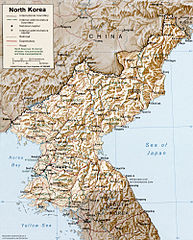
North Korea
CREATED/PUBLISHED [Washington, D.C. : Central Intelligence Agency, 1996]
NOTES Relief shown by shading and spot heights.
"Base 802497 (546979) 6-96."
Scale [ca. 1:3,500,000] ; Lambert conformal conic proj., SP 36N/40N (E 124 deg--E 130 deg/N 43 deg--N 37 deg).
SUBJECTS Korea (North)--Maps. Korea (North).
MEDIUM 1 map : col. ; 21 x 17 cm.
CALL NUMBER G7905 1996 .U5
REPOSITORY Library of Congress Geography and Map Division Washington, D.C. 20540-4650 USA
http://hdl.loc.gov/loc.gmd/g7905.ct001221
| This image is a work of a Central Intelligence Agency employee, taken or made as part of that person's official duties. As a Work of the United States Government, this image or media is in the public domain in the United States.
|

|
derivative works
Derivative works of this file: South hwanghae counties.png
Historial del fitxer
Cliqueu una data/hora per veure el fitxer tal com era aleshores.
| Data/hora | Miniatura | Dimensions | Usuari/a | Comentari | |
|---|---|---|---|---|---|
| actual | 01:10, 26 oct 2005 | | 1.608 × 2.000 (1,67 Mo) | Brian0918 | North Korea CREATED/PUBLISHED [Washington, D.C. : Central Intelligence Agency, 1996] NOTES Relief shown by shading and spot heights. "Base 802497 (546979) 6-96." Scale [ca. 1:3,500,000] ; Lambert conformal conic proj., SP 36N/40N (E 124 deg--E 130 deg |
Ús del fitxer
Les 2 pàgines següents utilitzen aquest fitxer:
Ús global del fitxer
Utilització d'aquest fitxer en altres wikis:
- Utilització a af.wikipedia.org
- Utilització a als.wikipedia.org
- Utilització a ar.wikipedia.org
- Utilització a ast.wikipedia.org
- Utilització a bs.wikipedia.org
- Utilització a de.wikipedia.org
- Utilització a el.wikipedia.org
- Utilització a en.wikipedia.org
- Utilització a eo.wikipedia.org
- Utilització a es.wikipedia.org
- Utilització a fa.wikipedia.org
- Utilització a fi.wikipedia.org
- Utilització a frp.wikipedia.org
- Utilització a he.wikipedia.org
- Utilització a hy.wikipedia.org
- Utilització a id.wikipedia.org
- Utilització a io.wikipedia.org
- Utilització a jv.wikipedia.org
- Utilització a ku.wikipedia.org
- Utilització a la.wikipedia.org
- Utilització a lb.wikipedia.org
- Utilització a lt.wikipedia.org
- Utilització a nds.wikipedia.org
- Utilització a nl.wikinews.org
- Utilització a oc.wikipedia.org
- Utilització a pl.wikipedia.org
- Utilització a qu.wikipedia.org
- Utilització a th.wikipedia.org
- Utilització a uk.wikipedia.org
- Utilització a vi.wikipedia.org